The Daniel Morgan Trail System
"The Dan"
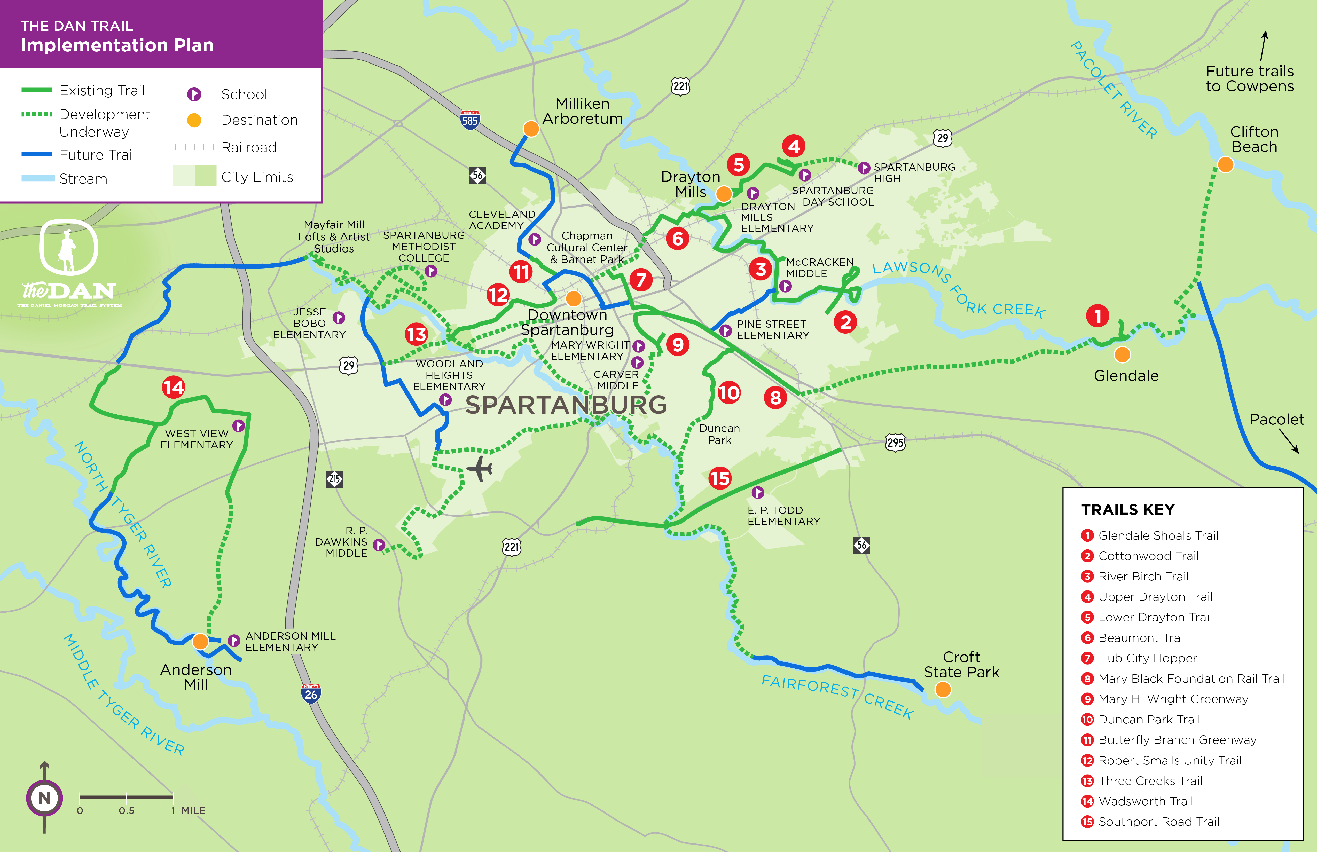
PAL is spearheading trail development in Spartanburg County’s urban area in collaboration with Spartanburg County Parks, the City of Spartanburg, and many community partners. This trail network, The Daniel Morgan Trail System or The Dan, is Spartanburg’s 55-mile urban trail system consisting of existing and proposed trails.
It is one of the region’s most transformative projects, linking residents across our community to jobs, educational opportunities, transit, and recreation. In fact, The Dan is the physical link connecting our tourism, environment, and health, as well as our economic, and community development projects.
| Dan Trail Map | Trail Infographics |
Existing Dan Trails
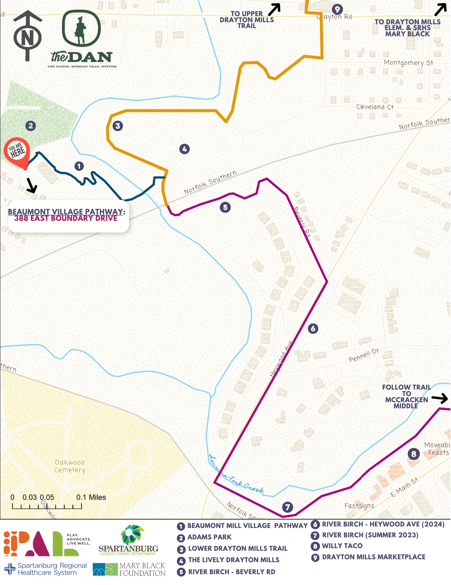
Beaumont Mill Village Pathway
Trailhead parking lot is located on East Boundary Dr.
Built by PAL, the Beaumont Mill Village Pathway connects to the Drayton Mills Marketplace and to Spartanburg’s downtown. The Pathway climbs from Lawson’s Fork Creek and the Drayton Mills Trails, making a few switchbacks up to Adams Park. From there, it will use the streets and sidewalks past the homes of the historic Beaumont Mill Village on its way to Pine Street and up Daniel Morgan Avenue into the downtown area.
Butterfly Branch Greenway
Behind Northside Harvest Park (near VCOM Carolinas)
Owned by the City of Spartanburg, the greenway is a visible sign of the Northside redevelopment project and connects to a Butterfly Creek that cultivates a fun, positive space for individuals of all ages to enjoy.
Cottonwood Trail
The trail can be accessed off of Beechwood Dr
Owned by Spartanburg Area Conservancy (SPACE), the trail is a part of the Edwin M. Griffin Nature Preserve, a 116-acre urban preserve and trail system.
Upper Drayton Mills Trail
Trailhead starts off Doctors Park Dr at the Spartanburg Medical Center- Mary Black Campus
Owned by Pacolet Milliken and maintained by Spartanburg County Parks, the trails connect into Drayton Mills Marketplace. Read more about the trail here.
Lower Drayton Mills Trail
Trailhead starts at the parking lot off Drayton Rd across from Drayton Mills Marketplace
Built by PAL and owned by Pacolet Milliken and maintained by Spartanburg County Parks, the trails connect into Drayton Mills Marketplace. Read more about the trail here. This trail is currently closed for construction; check back here for updates.
Duncan Park (walking & biking)
Walking - 0.6 miles
Biking- 6 miles
Trails main entrance is off Duncan Park Dr
Owned by the City of Spartanburg, the off-road biking trails wind and weave through the woods of Duncan Park.
Glendale Shoals
Located at the old Glendale Mill on Lawson's Fork Creek
Owned by SPACE, the Glendale Shoals Preserve consists of 13 acres and features a scenic waterfall that cascades over a dam.
Hub City Hopper
From E Henry St. trailhead to Daniel Morgan Ave.
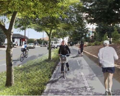
The first of it's kind in South Carolina. A potion is a traditional asphalt trail for all users, and the portion on Converse Street splits users with cyclists in the curb-protected asphalt lane and pedestrians on an extra-wide concrete sidewalk.
Mary Black Foundation Rail Trail
Located between South Pine St and Union St, the trail has access points at East Henry St and at Country Club Rd.
Owned by the City of Spartanburg as a critical segment of both The Dan and The Palmetto Trail, the trail includes Rail Tail Dog Park, Hot Spot Skate Park, a Spartanburg BCycle station and The Rail Yard Community Park.
Mary H. Wright Greenway
Trailhead starts at South Converse Park
Owned by the City of Spartanburg, the greenway includes a basketball court, two playgrounds, and a picnic shelter.
River Birch Trail
The trailhead starts off Sydnor Rd behind the old Spartanburg High School tennis courts.
Built by PAL and owned by the City of Spartanburg, the trail is paved and is a great place for families with strollers, bikes or wheelchairs. It has recently been expanded from East Main Street along the Lawson's Fork Creek to the Drayton Mills Trails by way of Heywood and Beverly Roads.
Three Creeks Trail
Built by PAL and owned by Spartanburg County and the City of Spartanburg, Three Creeks Trail consists of on and off-road segments and is where the Holston Creek, Fairforest Creek, and Three Mile Creek merge at Vanderbilt Road.
Wadsworth Trail
501 Willis Rd (The trail is three-pronged, with ending points on Willis Rd at Magnolia Park Estate, the intersection off Copperline Rd through the school property to intersect with Oak Grove Rd, and at the end of Caldwell Dr at Rock Springs.)
Owned by Spartanburg County Parks, the trail connects eight neighborhoods and the Westside of Spartanburg.
Wildflower Way
The trailhead starts off Sydnor Rd behind the old Spartanburg High School tennis courts.
Wildflower Way is a paved, ADA accessible path within the Edward Griffin Preserve, owned by Spartanburg Area Conservancy. With limited access to this natural area for people with mobility limitations and strollers, this segment will open nature to our Spartanburg community.
The trail is being constructed in three phases. Phase 1A is complete.
 |
 |
 |
Site by: ALINE, A Marketing Company